

Published April 30, 2026 08:21AM
The natural processes that shape the earth—the tectonic forces that create mountains and carve the ground beneath our feet—affect every aspect of our environment. In the past year, I’ve hiked crater rims atop active volcanoes and stood next to the world’s largest reversing waterfalls. Geologically spectacular areas exist in protected spaces all around the world, and not just in national parks. They’re in UNESCO Global Geoparks.
Designated by the United Nations Educational, Scientific and Cultural Organization, these areas protect some of the most geologically impressive landscapes on earth. They also incorporate hiking trails and stories of indigenous communities who have lived among the landscapes of these global parks for centuries. Today, you can explore 229 designated sites across 50 countries worldwide. Geopark visitors can explore everything from geometric basalt columns and gorges in Ireland and Korea to glacial kettle lakes in Finland and mineral-streaked mountains in China.
What Are Geoparks—And How Do They Differ From National Parks?
UNESCO Global Geoparks exist at the intersection of geology, education, and sustainable tourism. Within these protected territories, locals and visitors converge not only to enjoy the views but to examine the geological history that has—and continues to—define the culture and communities around it.
From ancient volcanoes and ice-age sculpted terrain to fossil formations and tectonic collisions, geopark landscapes tell a story 400 million years in the making. Each geopark showcases a unique environmental and societal tapestry tied into UNESCO’s mission of connecting natural history with human culture. They also serve as “living laboratories” for scientists and everyday adventure-seekers alike. Within geopark limits, visitors can explore some of nature’s rarest phenomena found on Earth.
Modern and Ancient Connections
What separates geoparks from our national park system is the relationship between the park and people who’ve lived among the landscapes for generations. National parks focus on monument preservation, protecting large swaths of land from development and removing pressures of modern life from impacting national park land. Geoparks operate on an entirely different philosophy. Surrounding communities aren’t considered a threat but an essential part of the park.
UNESCO’s Global Geopark designation requires people from local communities to be active stewards and storytellers of the land. For a park to maintain its designation, a site must demonstrate that locals are actively and genuinely involved in governance, education, and tourism, and not just employees or volunteers. Geopark programming and interpretation intentionally involves nearby residents, indigenous communities, historians, and local governments to make sure education reflects generations of lived experience in close relation to the land.
So, what sets a geopark hike apart from your typical national park adventure, exactly? The unique stories behind the people and terrain you walk. If you’re the type of hiker who’s less interested in the summit and more eager to learn the history of the trails you tread, it’s about time you added a geopark hike to your bucket list.
Where national parks pull crowds in the millions each year, geoparks tend to attract more intimate groups of curious and purposeful travelers interested in learning about nature and society’s co-existence from centuries ago to today. And unlike national park hiking, which can take you deep into remote wilderness, geoparks tend to sit on the doorstep of modern civilization. Many of them are just a short drive from a major city.
Two Geoparks That Belong on Every Hiker’s Bucket List
Ready to hike in a geopark? These two UNESCO Global Geoparks fly under the radar and offer rewarding trails with deep cultural and geological roots.
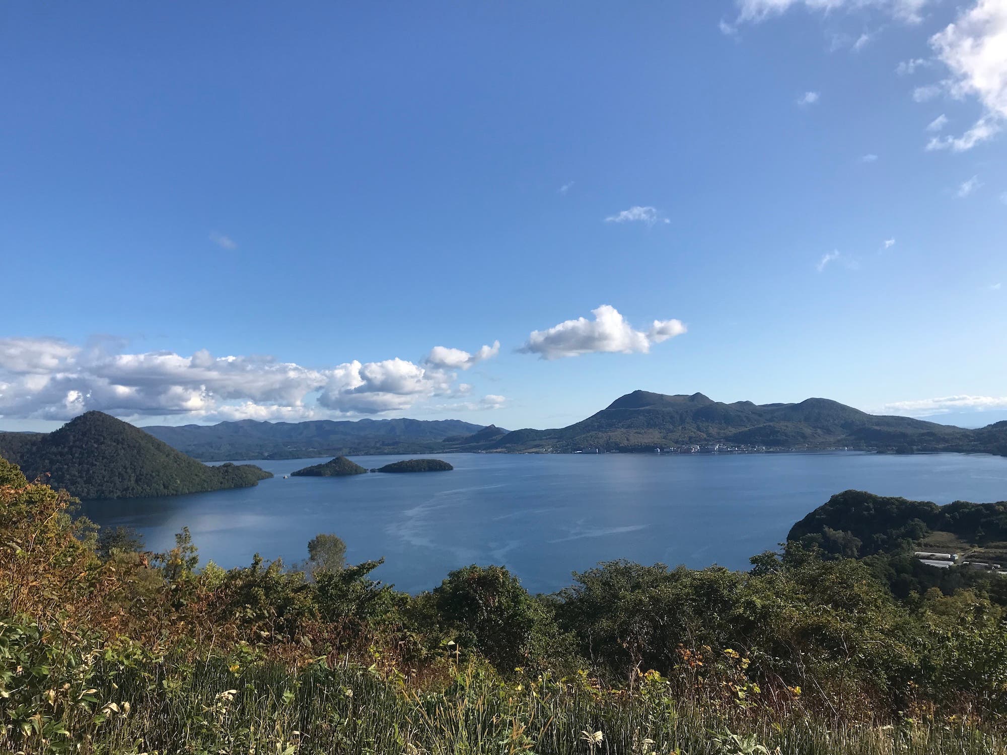
Toya-Usu UNESCO Global Geopark, Hokkaido, Japan
Japan’s northernmost major island, Hokkaido beckons adventurers with rugged, little-traveled terrain. The ancestral land of the Ainu people, Hokkaido’s terrain is elemental, full of active volcanoes, dense forests, and hot springs bubbling up from the earth. This natural and human history led to the designation of Toya-Usu UNESCO Global Geopark, a stretch of volcanic terrain riddled with crystal-clear caldera lakes. Unlike national parks, which protect a single defined area, geoparks encompass a vast region that encompass an ecosystem of designated landscape: regional parks, national parks, towns, farmlands, and coastline included. Within the broader bounds of Toya-Usu geopark, Shikotsu-Toya National Park is the fiery centerpiece.
Here Mt. Usu reveals the story of a region where the landscape and daily life have long been dictated by the power of one of Hokkaido’s largest active volcanoes. This highly active stratovolcano has erupted four times in the past century, most recently in 2000. In its shadow, local communities have developed a “disaster risk reduction culture” to safely coexist with the ever-present threat of volcanic activity.
To learn about Mt. Usu and the surrounding communities’ tumultuous volcanic history, book a guided tour with a Hokkaido local, like Rie Egawa, a “Volcano Meister” and guide for Mt. Usu. Her guided hikes with Sotoasobu Guides uncovers the dramatic history of Mt. Usu’s eruptions and the volcano’s impact on surrounding villages and landscapes.
If you prefer to chart your own course, choose from several mapped Mt. Usu volcano hikes. You can climb the short but steep 1.8-mile Mt. Usu Climbing Route (open late April through mid-November) that ascends to the base of the volcano’s crater rim. From the summit, either hike down or hitch a ride down the Mt. Usu Ropeway, a window-walled gondola that’s open year-round. From the drop-off at Usuzan Terrace, the 3-mile Mt. Usu Outer Rim Trail traces the crater rim out to an epic view from the Lake Toya Observation Deck before looping back.
If more solitude is what you’re after, try the Nakajima Island Loop. Hitch a 45-minute ferry from Lake Toya Onsen’s pier to uninhabited Nakajima Island at the heart of Lake Toya. Jump on the 5-mile Nakajima Island Loop that travels through thick stands of native Sakhalin spruce and Mongolian oak—a true forest bathing retreat.
Want more than a day-long adventure? Pitch a tent within the Toya-Usu UNESCO Global Geopark on the edge of Lake Toya at Akebono Park, near the base of Mt. Usu at Arutori-misaki Camp Site, or shoreline of Uchiura Bay at Okishi Seaside Campsite.
To round out your trip to the geopark, stop at Upopoy National Ainu Museum and Park in the coastal town of Shiraoi. Here you’ll learn about the largely untold history of Japan’s indigenous Ainu people. Nearby, Hoshino Resorts KAI Poroto hotel weaves Ainu culture into its design, with one of the most luxurious onsens in all of Hokkaido to match.
Stonehammer UNESCO Global Geopark, New Brunswick, Canada
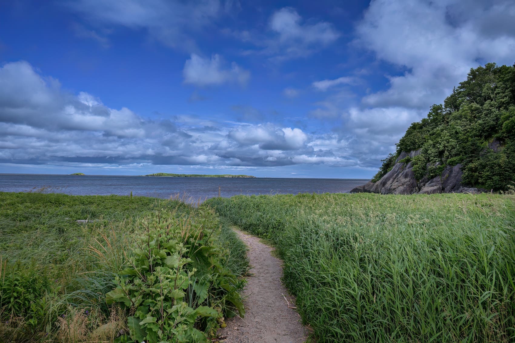
To catch a glipse of the world’s largest tidal swings from the top of a towering cliff, head to the rugged coastline of St. John, New Brunswick. This industrial town on Canada’s eastern edge pulls double-duty as a major marine trading hub and a gateway to coastal hiking. Its impressive wild side is still a secret to many hikers. Beyond its port, you’ll find ancient geology hidden in plain sight, surrounded by vast Acadian forests.
In 1857, a group of pioneering geologists exploring St. John’s natural history first studied the rocks around Stonehammer. What began as a scrappy group of geology enthusiasts yielded some of the most significant prehistoric discoveries of the century, like some of the first-ever Cambrian trilobites and Precambrian fossils recorded in Canada.
Start your hiking within the Stonehammer geopark at Irving Nature Park. The 600-acre, forest-engulfed peninsula hugs the rugged Bay of Fundy coastline and boasts drool-worthy views of the crashing waves. The 2-mile Seal Trail loop in Irving Nature Park follows the fossil-laced shoreline that captivated geologists to this region. For a longer hike, link the Seal Trail to the 1.6-mile Heron Trail. Its halfway mark dumps you at Seely Point Lookout, where a short detour gets you sweeping views of Saints Rest Marsh, Lorneville’s shoreline, and a well-maintained staircase that leads to a private sandy cove.
For an even more rugged hike, travel south of Irving Nature Park bounds to the 5.4-mile Split Rock Trail. This route cuts through some of Stonehammer’s most exposed geology marked by ancient volcanic and sedimentary rock naturally sculpted into dramatic outcrops and small coves. A longer 13-mile route linking Five Fathom Hole Trail and Black Beach Trail departs where Split Rock Trail ends, continuing along the cliffside with nonstop views of Musquash Harbor.
You can book a guided hike along any of these trails with In Step Adventures or Inside Out Nature Center (family friendly!) to get a local’s perspective on what makes the Stonehammer geopark so unique. They’ll help identify foliage, trees, and geology along the hike through Irving Nature Park and beyond, and share the ongoing story of how Saint John’s community stewards the land for generations to come.
By far, the most noteworthy geological spectacle in Stonehammer collides at the mouth of the Saint John River and the Bay of Fundy. Sea- and freshwater collide here twice a day. The sheer force of the Bay of Fundy’s tides propels the seawater through a 30-foot-deep rocky gorge—churning up rapids and massive whirlpools that flow in reverse at high tide and drain back out at low. Follow the action on foot along the accessible 3.4-mile Harbour Passage Trail, or catch it from above at the free viewing platforms in Fallsview or Wolastoq parks.
End your day with a trail-to-taproom finish at Moosehead Brewery, Canada’s largest independently owned brewery and a St. John institution for 160 years and counting. And don’t leave this area without checking out the historic Saint John City Market, which is the oldest continuing farmers’ market in all of Canada.