

Published April 1, 2026 03:11AM
The window to see snowmelt waterfalls may be earlier and tighter this season due to a “snow drought” across the western states through the winter months, but thanks to last-minute weather patten shifts, places like California and Washington have more rain and snow to runoff, stretching the season to witness some gnarly falls.
A snowmelt waterfall is a seasonal cascade that surges as the snowpack melts in the subalpine zone (between 3,000 and 8,000 feet in elevation) then diminishes—and in some places disappears—once the snowpack is gone in spring.
I recently traveled in Palouse Falls, roughly two hours southwest of Spokane, Washington, to witness one of the most powerful snowmelt falls in our region in its full glory. On a good year, Palouse Falls easily ranks within the top five snowmelt waterfall experiences in the country: it plunges 200 feet into a tight, basalt canyon, where the Palouse River surges wildly in spring.
But Palouse Falls is only one of many incredible places to catch this ephemeral event. Here are four others that offer encounters next to none.
Shoshone Falls, Idaho
Shoshone Falls in southern Idaho on the Snake River is known as the “Niagara of the West” and one of the largest waterfalls in the country. Standing at 212 feet high and about 900 feet wide, it is most magical between the months of April and June when it’s in full force from the snowmelt surge. According to Shoshone Falls Park, the falls can reach flows of more than 20,000 cubic feet per second during a spring that follows a winter with heavy snowfall. The most enchanting thing about Shoshone is its rainbows regularly seen during its surge.
History: Like many of these sites, Shoshone Falls was formed about 14,000 years ago during the last Ice Age. It—and Snake River Canyon—was carved out by flooding from Lake Bonneville. The first tourists were documented in the mid-19th century while using the Oregon Trail, but the falls were named in honor of the Native American tribe that occupied the land until the 20th century, when it began to be developed for hydroelectric use. Just before this, a vote was cast to protect the landmark and make it a national park, but Congress did not approve the proposal.
Tips while visiting: The drive into the canyon is winding and narrow, so prepare to take it slow. Large vehicles, like motorhomes, may have difficulty traveling through. The entrance fee is $5 for the day and covers Shoshone Falls, Dierke’s Lake, and Canyon Rim Trail. Dogs and drones are allowed.
Yosemite Falls, California
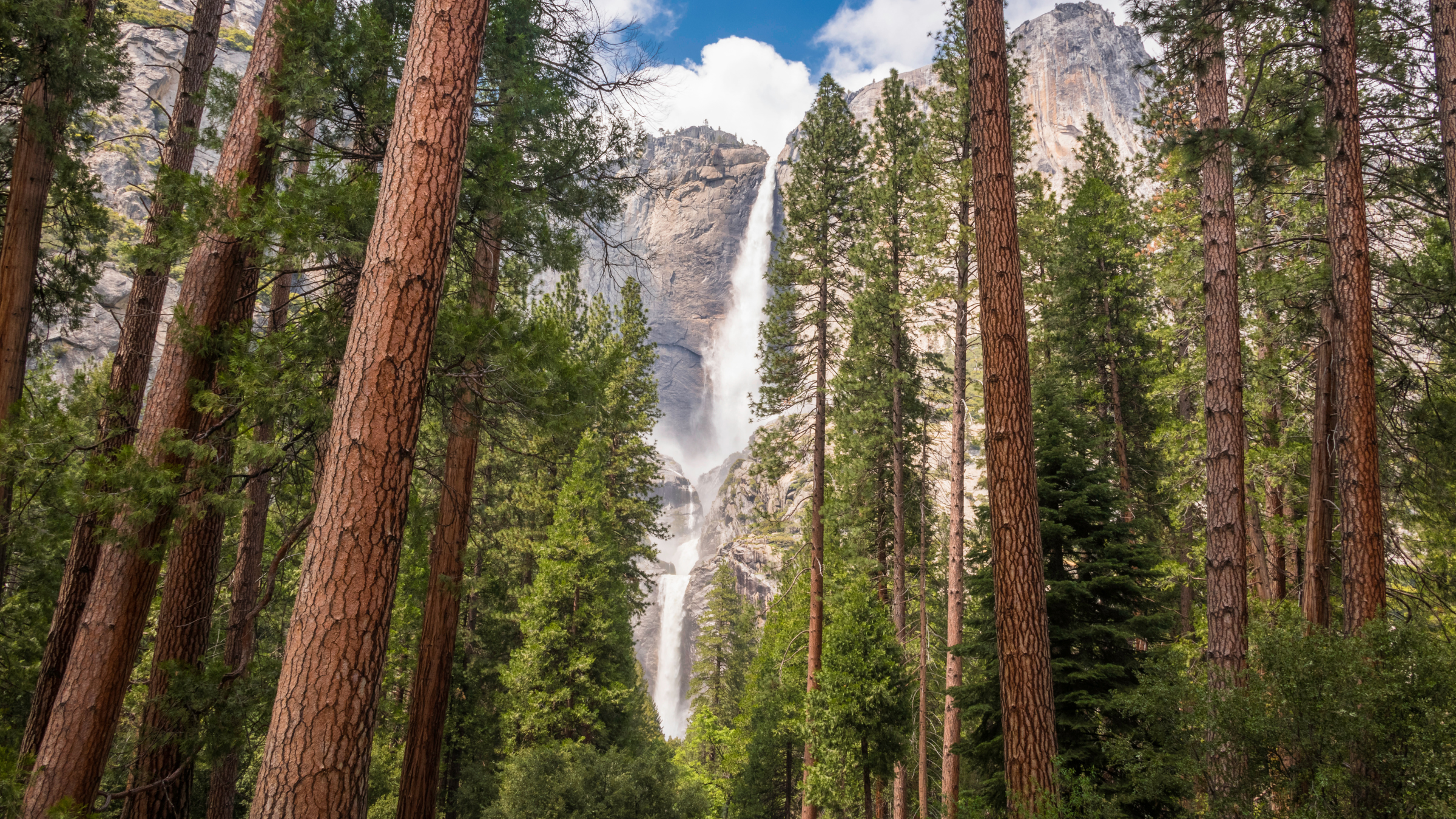
Yosemite Falls in Yosemite National Park is located in Mariposa Country, California, roughly two hours from Fresno. This three-tier waterfall isn’t just one of the country’s largest, but one of North America’s tallest. It plunges 2,425 feet from the rim of Yosemite Valley, and now is the best time to catch it in its fury. Peak viewing season will last through June this year thanks to a major February storm that put snowpacks around 70% of the average, according to Yosemite Conservancy. The nonprofit set up the Yosemite Falls webcam for virtual viewing, but nothing compares to standing beneath it.
History: For millions of years, there were glacial periods where massive sheets of ice moved through Yosemite Valley from the high country before retreating back. The most recent occurrence was about 20,000 years ago, according to the NPS, when a glacier traveled as far as Bridalveil Falls, covering two-thirds the height of the cliffs. Yosemite didn’t used to cascade off the steep stone edge, but glacial debris diverted it, creating one of the world’s highest waterfalls.
Tips while visiting: A standard pass (about $20 for the day), annual pass ($70), or America the Beautiful Pass is required to enter the park. For two to three hours out-and-back, you can climb to Upper Yosemite Falls to view them up close, as well as Half Dome and other Sierra mountain peaks. Check the weather and current conditions before heading out.
Note: Yosemite is also home to three other powerful snowmelt waterfalls: Vernal, Nevada, and Bridalveil Falls. Vernal is a 317-foot waterfall, and Nevada a 594-foot waterfall, both located on the Merced River. Bridalveil is the more prominent of the three waterfalls that hangs from the south side of Yosemite Valley at 620 feet.
Snoqualmie Falls, Washington
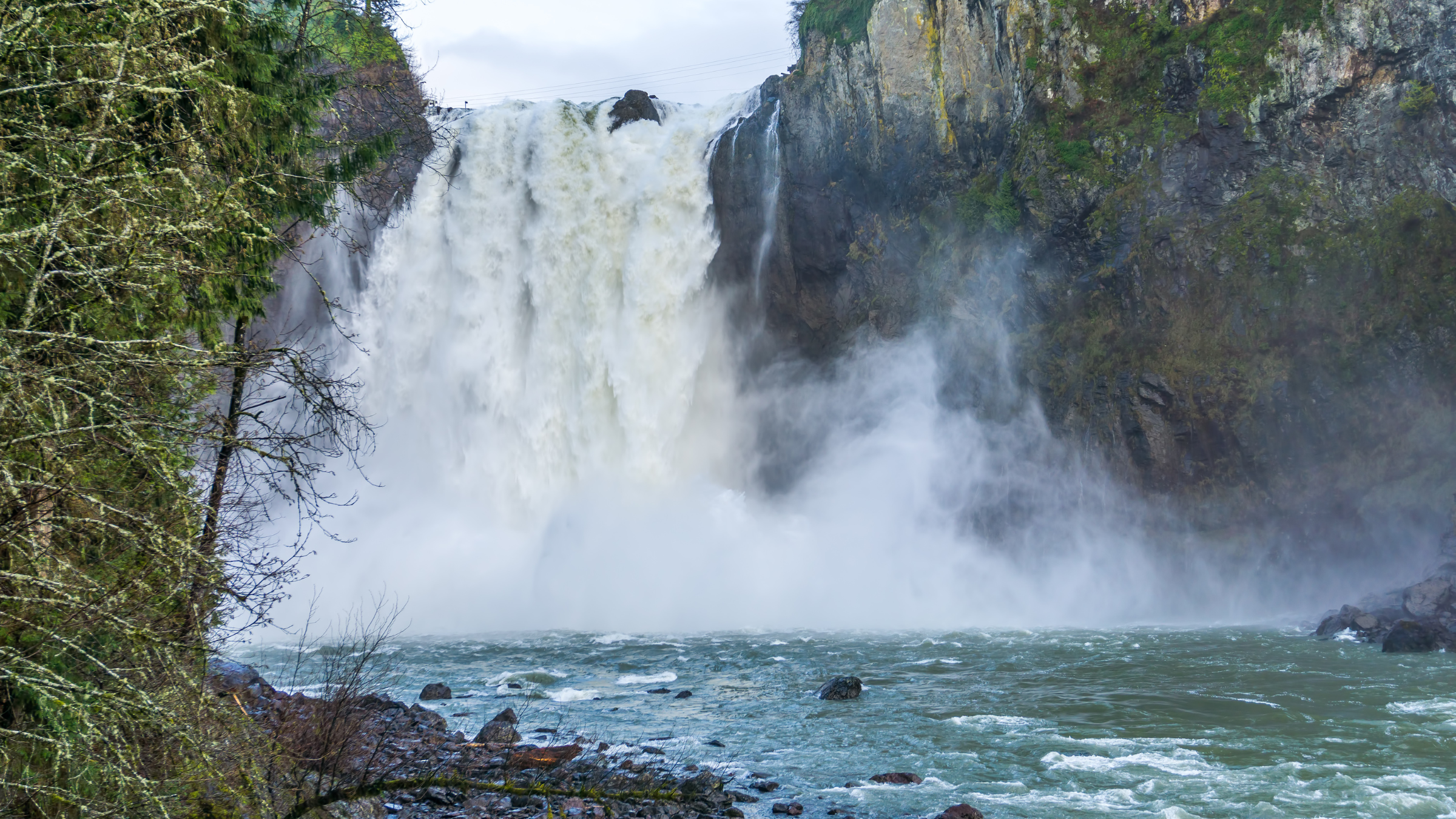
Snoqualmie Falls, though only 268 feet in height, is set apart for its dramatic drop, beauty, and cultural significance. This popular landmark is located on the Snoqualmie River near Seattle on the western slope of the Cascade Range, and sees 1.5 million visitors each year. Like the falls, the river also plunges from a basalt ledge into a deep gorge. During snowmelt season, the combined flow creates a mist that’s visible for miles. According to media reports, recent heavy snow and rainfall has flooded some areas of the Snoqualmie River this year, making the falls very powerful at the moment.
History: Like most of these falls, Snoqualmie was created by glacier flow several thousand years ago. The Snoqualmie Tribe were the first to occupy the land, finding a fertile plain and plenty of wildlife. White settlers began to arrive in the valley in the 1850s and began logging and milling operations. By 1890, a power plant was created at the falls, and most of the tribe was scattered. It remains a sacred site to the Snoqualmie people who recently purchased back 45 acres surrounding Snoqualmie Falls in hopes to reconnect to and restore the land.
Tips while visiting: There’s free parking in the upper and lower lots until full, then parking is paid. Since Snoqualmie is a tourist spot, there are gift shops, restaurants, and two observation decks, but the public areas are closed on Mondays and Tuesdays. Hikers can still access the surrounding trails, like Snoqualmie Falls Trail, a 1.5-mile out-and-back with a view of the falls, any day of the week with a Discover Pass.
Palouse Falls, Washington
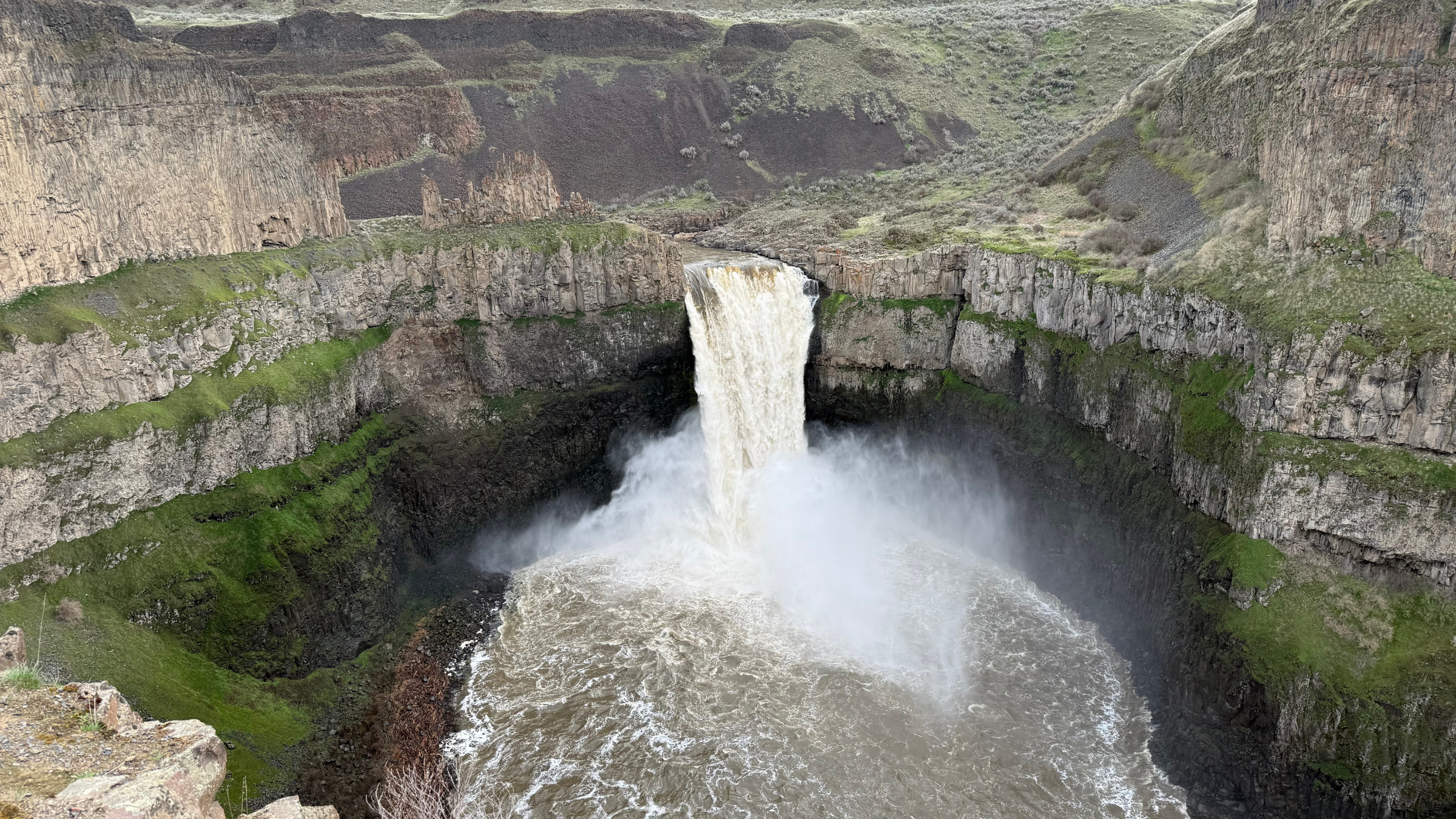
Palouse Falls, located at Palouse Falls State Park in southeastern Washington, about two hours from Spokane, is a major geological and scenic landmark. It’s about 200 feet tall and flows into the Palouse River, which offers 94 acres of recreational area and hiking trails down and around the basalt cliffs carved out about 15,000 years ago. Recent rain and snowmelt are causing the Palouse to surge right now, as I witnessed firsthand. Locals say the breathtaking scene will likely last through early May.
History: During the last ice age, glacial sheets blocked may of the valleys, creating pools of water that drained rapidly, forming the landscape you see now. Before that, water didn’t exist here. The Palouse River flowed in a different direction. It jumped course after floods that fractured the basalt beneath the hills. But the cliffs you see were formed by vast lava flows that covered eastern Washington millions of years ago.
Tips while visiting: There is an automated pay station as you enter the park where you can purchase a day-use or annual Discover Pass. Palouse Falls is a popular site, so expect a crowd most days. Trailer and RVs cannot enter the park, since the road in is narrow and there aren’t any turnarounds. Nearby Lyons Ferry State Park has some really fun swimming and picnicking spots.
Upper Mesa Falls, Idaho
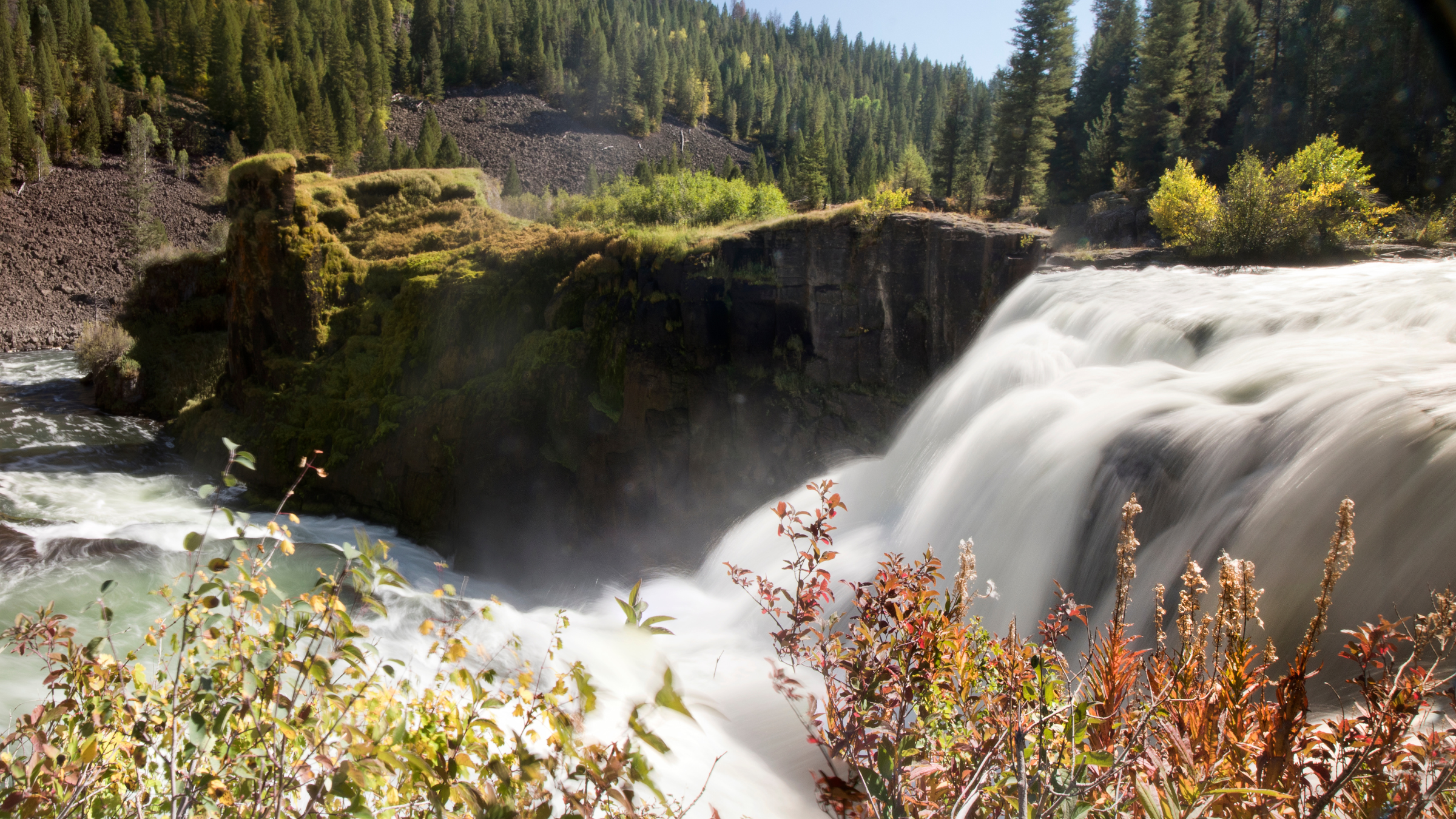
Upper Mesa Falls in Fremont County, Idaho, sits at 114 feet high and 200 feet wide during peak season, lasting through early June. Located on the Snake River, near the town of Ashton, it is one of the last significantly sized undammed waterfalls in the state, that pours over what remains of an ancient volcanic eruption, similar to that of Palouse Falls. In the summer, the Mesa Falls Visitor Center is open daily with trail information available.
History: Mesa Falls is intertwined with the same volcanic hotspot as Palouse Falls, from Yellowstone millions of years ago, but a single eruption about 1.3 million years ago produced the landscape that allowed the falls to flow. The waters originated from Island Park springs (among the 40 largest springs in the country, 22 miles south of Yellowstone), home to a highly sought-after population of trout. The Caribou-Targhee National Forest works hard today to protect the landscape from the effects of climate change and to ensure ecological health.
Tips while visiting: Upper Mesa Falls requires a $5 vehicle fee unless you have an Idaho State Parks Pass. Otherwise, you’re free to roam around. Expect to see bald eagles, osprey, and marmots, and consider exploring Mesa Falls Nature Trail, a two-mile out-and-back that allows you to see both the upper and lower falls.