
Updated May 15, 2026 08:06AM
The parking lot at Newfound Gap inside Great Smoky Mountains National Park had a Trader Joe’s vibe to it, with minivans and SUVs jockeying for limited spaces. I was excited to knock out a run on the Appalachian Trail, which cruises through a high-elevation spruce-fir forest, but first I had to find a parking spot. I circled. I waited. I circled again.
Such is the reality of visiting a popular national park on a busy weekend. There are lines. There are reservation windows. There are crowds at overlooks and single-file marches on certain popular trails.
The National Park Service released its annual visitation data, and yet again the top five most popular national parks got a whopping 31.94% of all visitors in 2025. The top 10 national parks accounted for more than 51% of all visitors last year. I understand why we’re all flooding to these national parks; they’re awesome. Great Smoky Mountains National Park (11,527,939 visitors last year) is one of the most biodiverse landscapes in the world. It’s a lush forest with waterfalls tumbling out of every holler. In Yellowstone (4,762,988 visitors), the water is practically boiling. And don’t get me started on that beautiful ditch at the heart of Grand Canyon National Park (4,430,653 visitors). But there are other fantastic landscapes out there within the national park system.
These are 5 less-crowded alternatives to the most popular national parks in our country. I chose some of these parks because of their proximity to their more popular cousins, while others I picked because of similar terrain. But all of them are stunning, and they all regularly attract a fraction of the crowds that the perennial favorite national parks get. And that means you won’t have to battle for a parking space, or stand in line at the overlook to take a picture.
Instead of Great Smoky Mountains National Park, Visit Congaree National Park
It’s tough to find a comparison for Great Smoky Mountains National Park. This is the most visited park in the country and has the most biodiversity of any park unit in America. It’s also super accessible, situated in the Southern Appalachians within a day’s drive of more than half of the U.S. population.
While Congaree National Park might be smaller (just over 26,000 acres), it’s located off a major interstate in the middle of the East Coast, sharing GSMNP’s proximity to the majority of the country’s population. In other words, Congaree is convenient, much like the Smokies, and it’s incredibly biodiverse, being home to one of the oldest and tallest tree canopies east of the Mississippi. You’ll find massive bald cypress, tupelo, and pine trees inside the park, which you can observe on foot or by boat; Congaree is situated on a floodplain with miles of marked canoe trails inside its borders.
The Easy Hike: Fork Swamp Trail
This 0.6-mile hike follows an oxbow lake that was formed by a hurricane in the mid-1800s. It’s flat and gives hikers a chance to see the park’s amazing collection of animals, from bald eagles in the treetops to river otters in the lake.
The Full Adventure: Paddle the Cedar Creek Canoe Trail
The best way to explore Congaree is from the hull of a boat. Put in at Bannister’s Bridge and follow the marked Cedar Creek Canoe Trail toward the Congaree River, which forms the border of the park, paddling between stands of 500-year-old bald cypress trees along the way. The water is the color of tea and is slow-moving, so you can approach this paddle as an out-and-back and pick your distance. If you want a big adventure, paddle a 20-mile overnight trip from Cedar Creek Landing to the 601 Landing on the Congaree. Snag a free backcountry camping permit at the visitor center. If that’s too ambitious, Palmetto Outdoor offers guided day trips ($100 per person).
Camping in Congaree
Congaree has two frontcountry campgrounds, but the Bluff Campground has the right combo of access and remoteness; tt requires a mile-long hike, but sits well above the floodplain so you can pitch a tent on firm ground. Book a reservation up to 6 months in advance on a rolling basis ($10 a night).
Instead of Rocky Mountain National Park, Visit North Cascades National Park
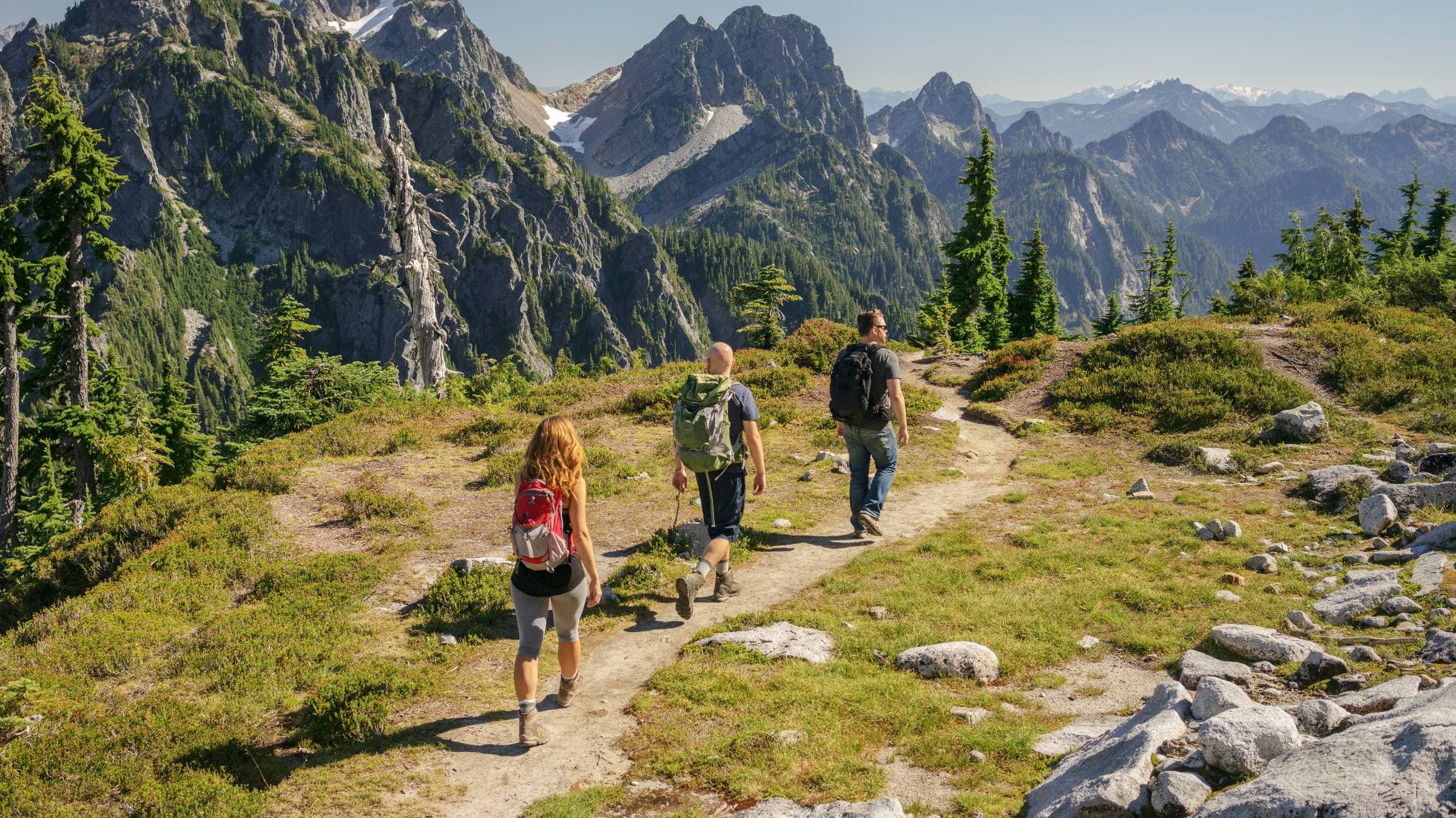
Rocky Mountain National Park’s appeal is obvious. The massive park protects a 415-square-mile swath of high-elevation peaks, glaciers, and backcountry lakes. It’s alpine terrain at its best, and Rocky Mountain is always in the top 10 most visited parks in the country. But North Cascades, in Washington, actually does alpine terrain a little better. Looking for a horizon full of towering, jagged peaks? The Cascade Range is steep and rugged, with the highest peak in the park, Mount Baker, topping out at 10,781 feet. And North Cascades has more glaciers than any other spot in the Lower 48 (300), and is punctuated with backcountry lakes and wildflower-covered meadows. Sounds a little like Rocky Mountain National Park, doesn’t it?
All of this grandeur is just three hours east of Seattle, and yet North Cascades National Park is one of the least visited parks in the contiguous United States, drawing just 46,925 people in 2025. To put that in perspective, more than 68,000 people visited Longs Peak, a single mountain inside Rocky Mountain National Park, in the same timeframe last year.
So why so few visitors to North Cascades? The terrain is rugged, there aren’t a lot of amenities, and roads through the park are minimal, so visitors looking for a “drive-through” park experience don’t have much to do. But if you’re up for an adventure, the entire 504,654-acre North Cascades National Park can be yours.
The Easy Hike: Thunder Knob Trail
This relatively straightforward 3-mile out-and-back traces along the edge of the Thunder Arm of Lake Diablo climbing to the head of Thunder Knob, where you’ll have a broad view of the massive lake below and the glaciated peaks of the park on the horizon. The trail starts at Colonial Creek Campground, and the path is easy enough for children to tackle.
The Full Adventure: Hike to Sourdough Lookout
This 10.4-mile out-and-back is considered one of the most strenuous day hikes in the park, largely because it gains almost 5,000 feet along the way. The hike begins near the town of Diablo off State Route 20 and switchbacks upward through a mix of dense forest and open meadows before reaching the rocky peak of Sourdough Mountain, where a historic lookout cabin awaits. This is the cabin that hosted beatnik poet Gary Snyder in the 1950s. From inside the cabin, you can enjoy long-range views of the park’s lakes and glaciers in every direction. The large Diablo Lake sits to the south, flanked by the Pyramid and Colonial peaks.
Camping in North Cascades
Colonial Creek North Campground, on Diablo Lake, has 38 sites, most of which are tucked into a pine forest, and multiple day hikes beginning from the campground. Reserve six months in advance. It is only open from May through September ($24 a night).
Instead of Zion National Park, Visit Capitol Reef National Park
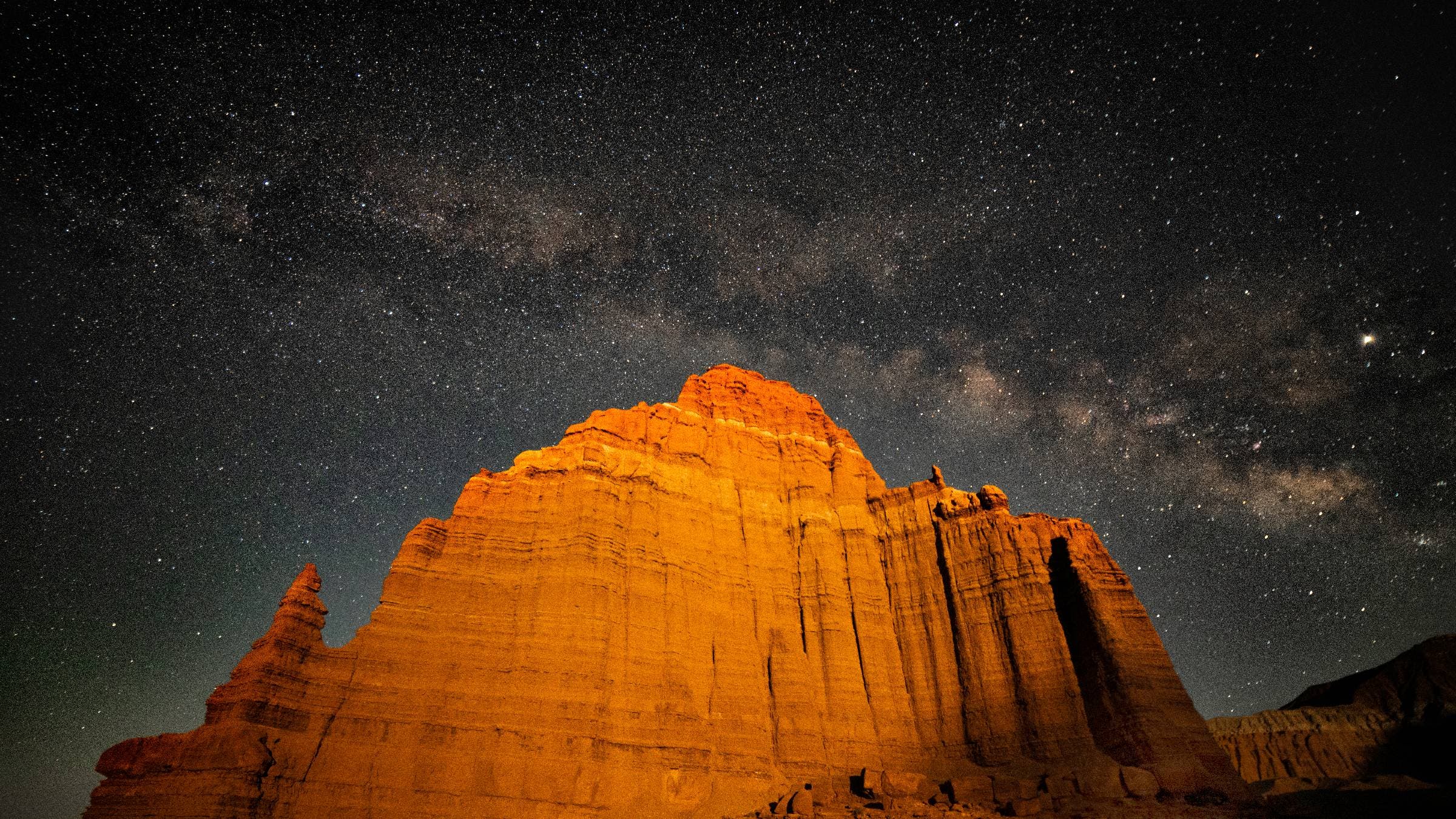
Capitol Reef National Park, in Southern Utah, saw 1.38 million visitors in 2025, which is nothing to scoff at, but it’s roughly a quarter of what Zion National Park endured last year. While you won’t find Zion’s crowds at Capitol Reef, you will find similar terrain. The park encompasses more than 240,000 acres of desert, loaded with rock towers, slot canyons, cliffs, and natural arches. Visitors have a diverse array of adventures at their disposal, from frontcountry hikes off scenic roads to challenging canyoneering routes deep in the backcountry. Capitol Reef is one of the most adventurous national parks I’ve ever experienced. I spent a weekend hiking and camping in Capitol Reef last fall and kept wondering why more people weren’t flocking to the landscape.
The Easy Hike: Grand Wash Trail
Grand Wash has access directly off Capitol Reef’s scenic drive and gives day hikers a taste of the slot canyon landscape without the inherent risk. The 4.4-mile out-and-back wanders through a canyon with 200-foot-tall walls that gradually get narrower as you hike toward the center of the gorge. The hiking is flat and sandy, and after a mile, you’ll reach the narrowest point of the canyon, with the passage roughly 20 feet wide. It’s an easy out-and-back that’s great for families with small children.
The Full Adventure: Lower Spring Canyon
For those looking for a milder canyoneering adventure with easy access, venture into Lower Spring Canyon, 9.5-mile point-to-point hike starting at the Chimney Rock Trailhead on Highway 24 and running to where Highway 24 crosses the Fremont River. It’s not an official trail and the route is unmarked (you’ll find cairns along the way), but it’s not a technical descent since the dry falls that need to be negotiated have bypass trails that don’t require ropes. It is an adventurous hike though, with scrambling, some narrow slot sections, and a mandatory ford of the Fremont River toward the end of the journey.
Camping at Capitol Reef
Capitol Reef’s 71-site Fruita Campground is situated near the Fremont River Valley and gives off an oasis vibe that has been attracting visitors for centuries. In fact, Mormon pioneers settled here and planted fruit orchards in the late 1800s. Some of the trees are still living, and you’re allowed to pick the fruit when it’s in season. (Starting at $25 a night; you can make reservations up to six months in advance).
Instead of Yellowstone National Park, Visit Lassen Volcanic National Park
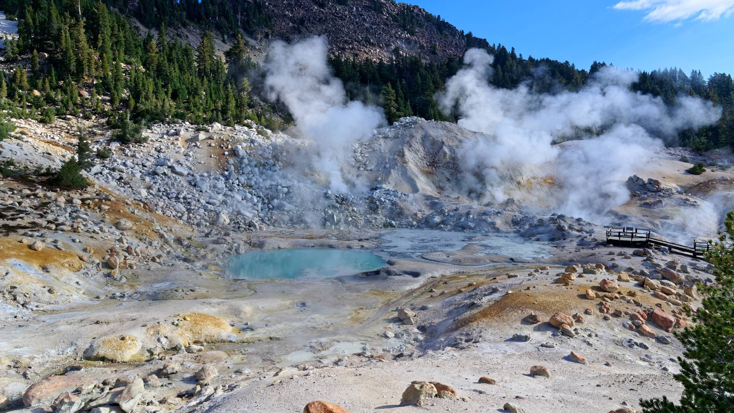
You like hydrothermal features? Lassen Volcanic National Park has hydrothermal features in spades thanks to the 40 volcanoes that are located within the park’s 106,372 acres. That sort of geothermal activity has resulted in countless bubbling mud pots, steaming fumaroles, and hot springs, much like you’d find inside Yellowstone National Park. And the super-hot water is just the beginning. Lassen sits in the northeastern corner of California with peaks that rise to almost 11,000 feet, and a diverse landscape that includes high alpine meadows, backcountry lakes, and dense hemlock and pine forests. And yet, Lassen is one of the least visited national parks in the country with just 504,777 visitors last year.
That just means you won’t have to jockey for a view as you hike through the steaming landscape. Just be sure you time it right. Between November and May, the entire park is covered in snow, drawing more than 30 feet of snow each year, and cross country skiing and snowshoeing take over. Although winter has its appeal. Sledding is common on the steep slopes behind the Kohm Yah-mah-nee Visitor Center, while backcountry skiers head to the higher peaks.
The Easy Hike: Bumpass Hell Trail
This is a straightforward 3-mile round trip on a packed gravel path and boardwalk through the largest hydrothermal area in the park. The Bumpass Hell area is a valley of mostly barren land, void of most plant life, with small, colorful pools of piping hot water, boiling mud pits, and numerous vents shooting steam into the air. Remember to stay on the trail, especially in boardwalk areas around the hydrothermal pools—that’s boiling acidic water down there.
The Full Adventure: Terminal Geyser Trail
Lassen’s Warner Valley is a more remote section of the park with its own trail system and suite of hydrothermal features. This 6-mile out-and-back on the Pacific Crest Trail passes by a few stunners, including Boiling Springs Lake, a milky white pool that’s kept at 125 degrees year-round thanks to steam vents that line the base of the pool, and Hot Springs Creek, which is—you guessed it—a creek loaded with hot springs. Don’t think about soaking in these pools—the water is highly acidic. The showstopper is the Terminal Geyser, an opening in a hillside that spews piping hot steam and water out of the earth. It’s not the show you find at Old Faithful, but it’s still impressive. The thermal features are the main attraction, but you’ll also hike through pristine meadows with lush grass and through healthy conifer forests.
Camping at Lassen Volcanic
There are eight campgrounds inside the park, but Butte Lake Campground offers immediate access to the namesake lake, which is lined with lava rocks, as well as proximity to the popular Cinder Cone Trail. Reservations are required ($22 a night).
Instead of Grand Canyon National Park, Visit the Black Canyon of the Gunnison National Park
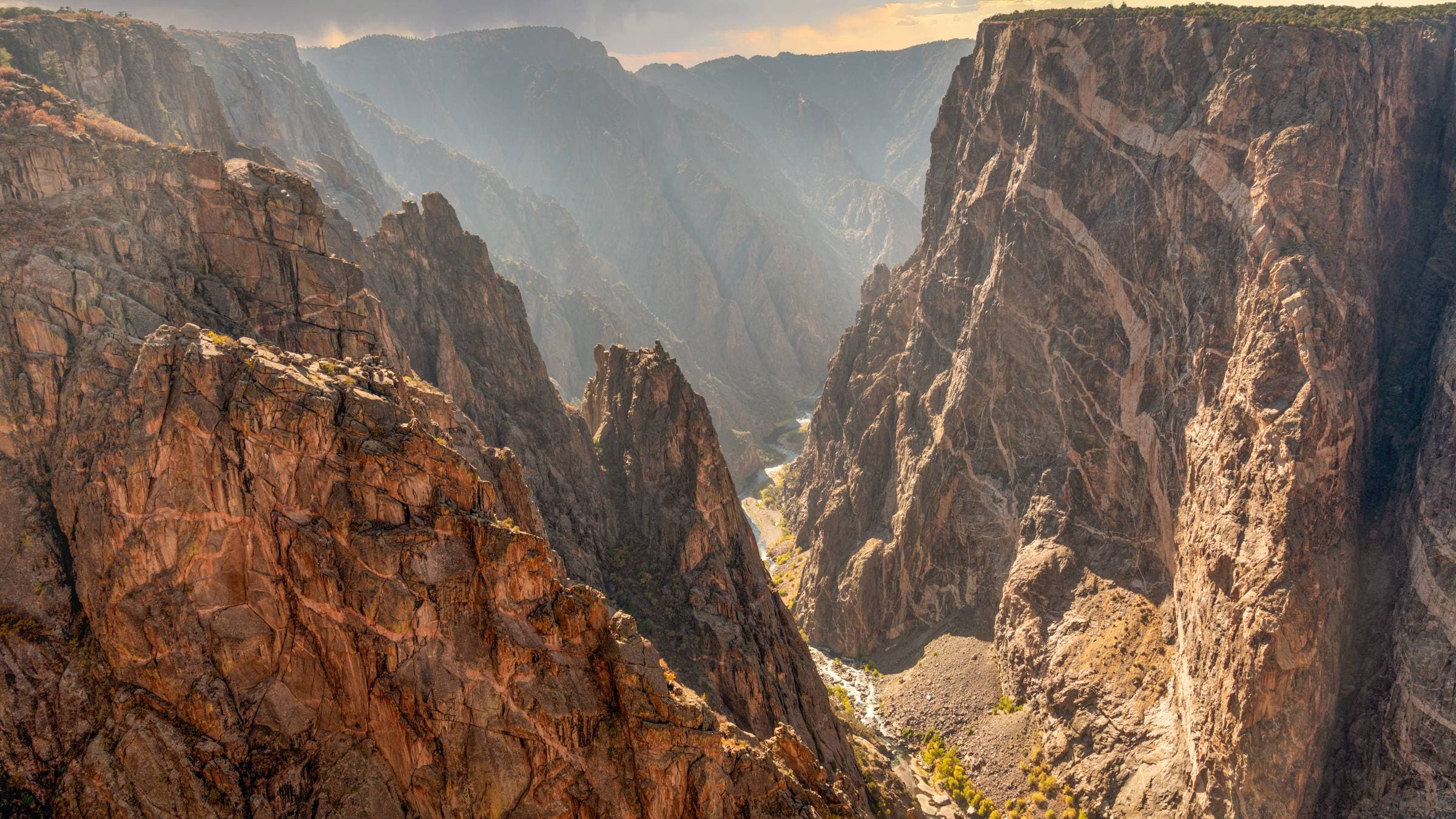
Ok, I’m not suggesting the Black Canyon of the Gunnison is on the same level as the Grand Canyon. The size and scope of these two canyons don’t compare. But Colorado’s Black Canyon is an impressive ditch in its own right, winding through southwestern Colorado for 48 miles and measuring 2,722 feet at its deepest point. And the walls are steep…so steep that the National Park Service calls the park a “vertical wilderness.” And while the Grand Canyon gets 4.9 million visitors a year, the Black Canyon of the Gunnison saw just 250,086 last year.
Much like the Grand Canyon, the Black Canyon of the Gunnison is a tough canyon to navigate, with no bridges connecting the North Rim and South Rim. The South Rim is more developed, with a dozen overlooks, a visitor center, and a large campground. The North Rim is more primitive, with a gravel road providing access to a few developed trails and a handful of overlooks. The South Rim Drive is paved along the canyon rim for seven miles with 12 overlooks between Tomichi Point and High Point. Driving this road is a good way to get a sense of the depth of the canyon. A wildfire damaged much of the South Rim of the park during the summer of 2025, but the South Rim Road and visitor center have reopened. The South Rim Campground and East Portal Campground remain closed.
The Easy Hike: North Vista Trail
I normally send people to the Rim Rock Trail for an easy stroll along the South Rim of the canyon, but the recent wildfire has closed the majority of that trail. Don’t worry, the North Vista Trail offers big views in a short distance as it follows the North Rim of the canyon through a pinyon and juniper forest with several overlooks that peer down into the inner canyon. You can stop at Exclamation Point for a relatively easy 3-mile out-and-back. But if you really want a view, double your mileage and continue hiking all the way up to the top of Green Mountain where you’ll have a view of the canyon below and the San Juan Mountains on the horizon.
The Full Adventure: The Warner Route
The inner canyon is a raw wilderness experience that is not for the faint of heart. In fact, less than 1% of the park’s visitors even bother exploring the inner canyon. There are no official trails leading down into the canyon, only unmarked adventure routes that require down-climbing, scrambling and route-finding. These routes make the established trails inside Grand Canyon National Park look like moving sidewalks. Some of the most popular routes that descend into the bottom of the canyon are closed for rehabilitation after the summer wildfire, but the Warner Route, on the South Rim, is still open. The route begins at the end of the Warner Point Nature Trail at Warner Point. It’s a massive endeavor, dropping more than 2,700 feet in 3.5 miles to the edge of the Gunnison River. It’s a full-day adventure to get down and up along the Warner Route. You don’t need technical gear, but you can expect plenty of hand-over-hand climbing, loose scree, and the occasional chain placed to help you through steep sections. You’ll need to get a permit in advance ($4 recreation fee, $6 reservation fee). Bring a fly rod, too; the Gunnison River within the park’s boundaries is known for its massive rainbow trout.
Camping at Black Canyon of the Gunnison
While the larger South Rim Campground is still closed, the North Rim has a smaller campground with 13 sites separated by piñon and juniper trees ($20 a night, first-come, first-served).
Graham Averill is Outside magazine’s national parks columnist. He loves avoiding crowds in the busiest parks and recently covered how to book a great national park campsite every time.