

Published May 19, 2026 03:33AM
No matter how good you feel or how fast you’re moving, at some point on most climbs, a little voice inside you starts to ask: How much farther to the top? It’s a fair question. But you’d hope it wouldn’t start quite so early.
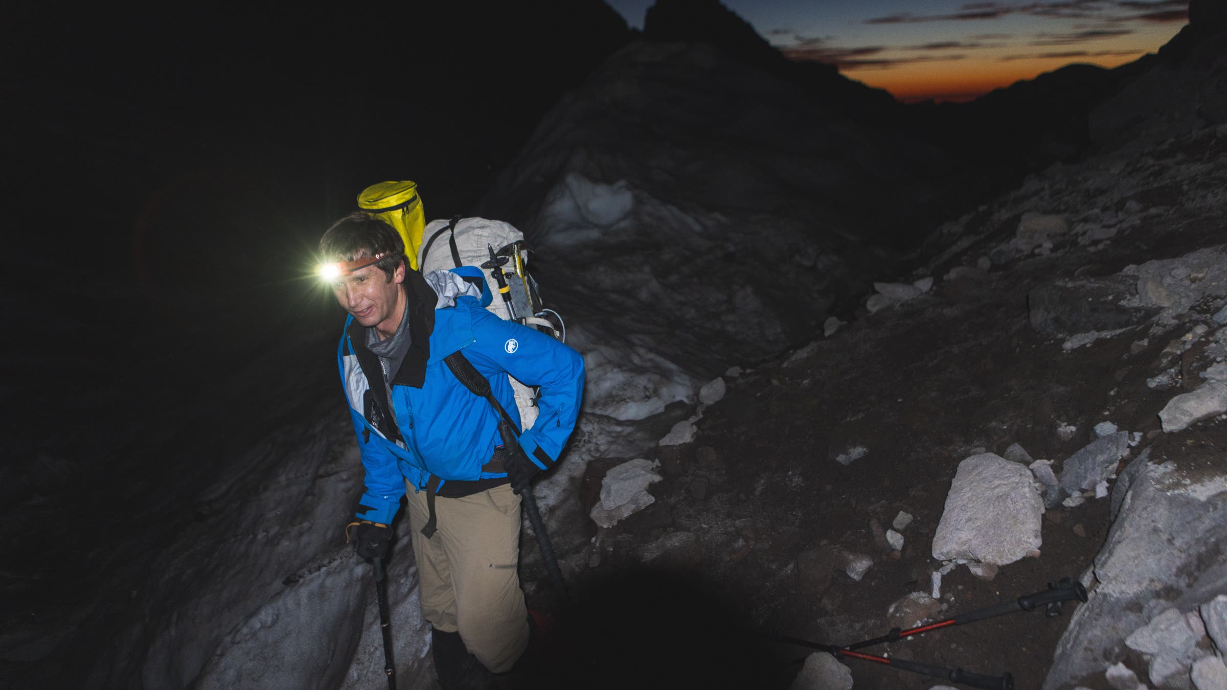
It’s 5 a.m. and a small army of us have been climbing Mount Rainier since midnight at a non-recreational pace. Those who slept last night managed maybe an hour in their cars. Now, at sunrise, we’re exhausted and falling behind schedule.
Somewhere below, a second platoon is likely just waking up, preparing to start their own climbs to three different U.S. Geological Survey (USGS) survey markers at the Paradise Visitor Center, McClure Rock, and the Camp Muir helipad.
The project feels military in scope, if not exactly precision, and there is no doubt today that precision is preferred.
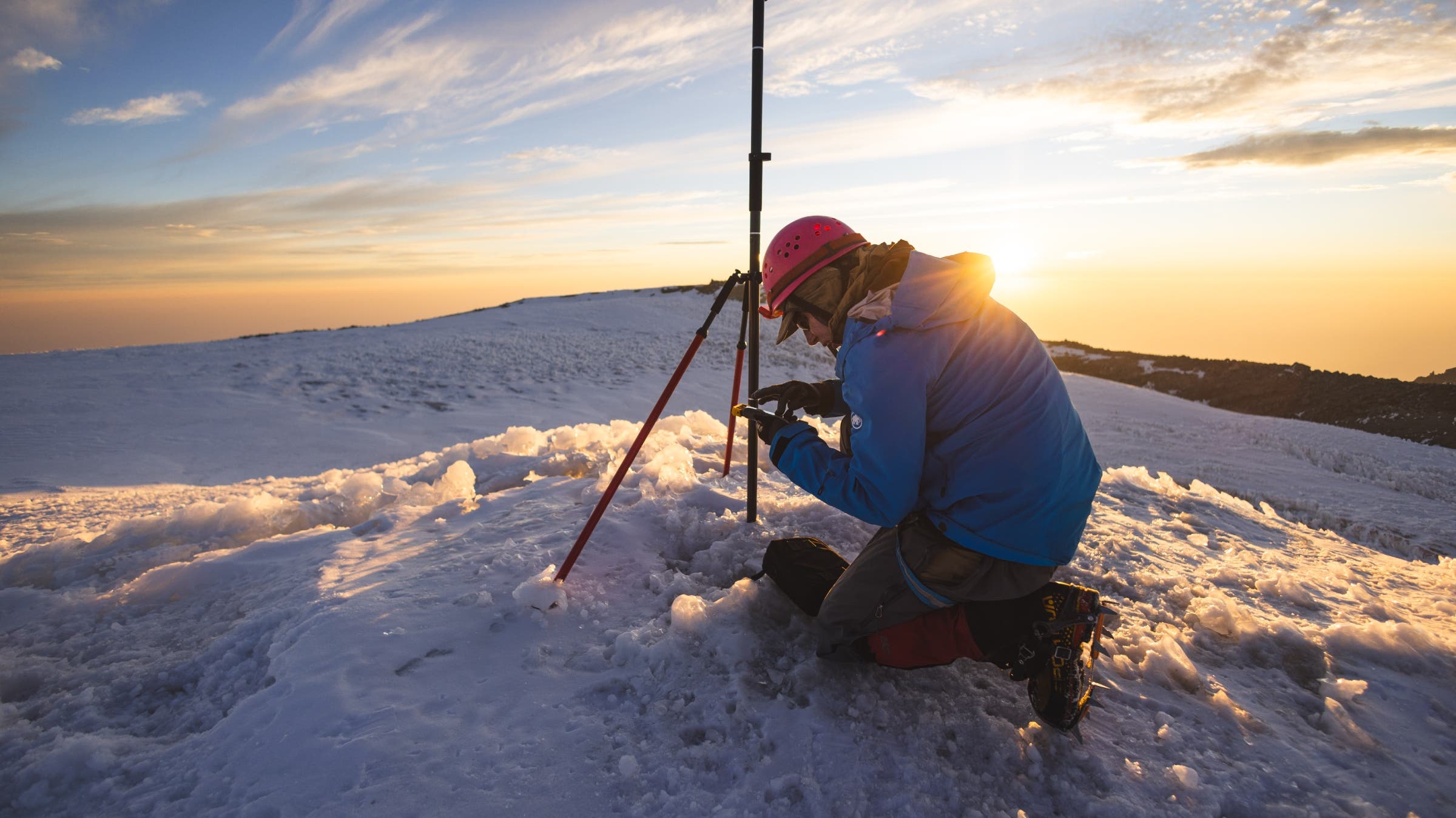
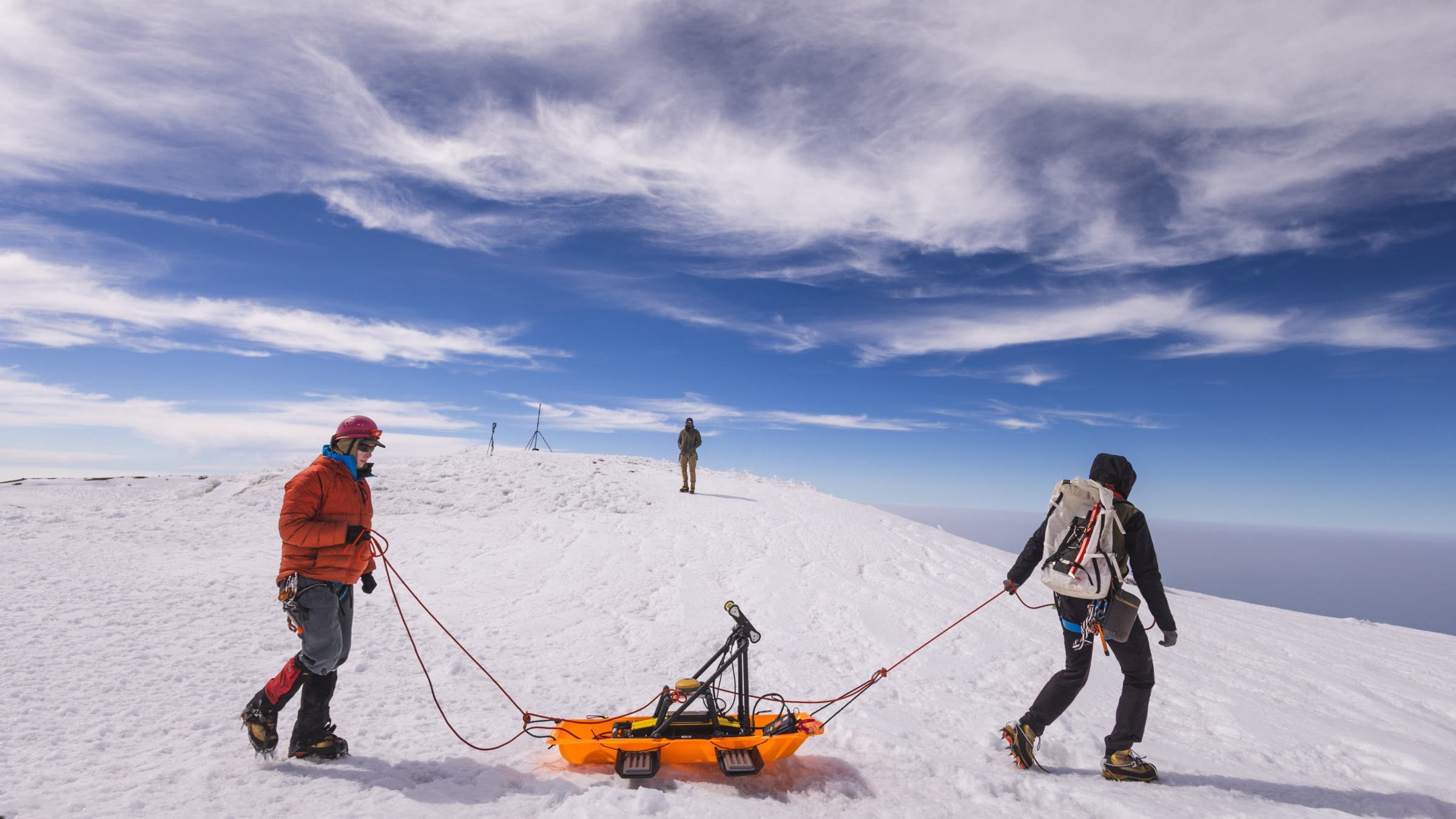
If all goes according to plan, our team of six will reach the summit just as everyone else hits their own marks. Then, we’ll all simultaneously set up carbon fiber tripods and professional-grade Global Navigation Satellite System (GNSS) receivers in order to take two hours of concurrent readings from five different locations. The goal is to determine—to the inch—the height of this mountain.
Savvy readers may note that the height of Rainier, Washington state’s most iconic mountain, is no mystery. That it has already been thoroughly measured, many times, and that if one wants to know its official height—14,410 feet—one need only adventure as far as the gift shop in Paradise, where the number seems to be printed on everything.
Truly devoted Rainier-ites may also note that the official height was calculated by hand in 1956, with a two-foot margin of error. GPS measurements from the summit in 1988 and 1999 put the height at 14,411 feet.
We’re climbing today because they’re both wrong.
Probably.
Eric Gilbertson, our team leader, is an associate teaching professor of mechanical engineering at Seattle University. He is also one of the world’s foremost peakbaggers and something of a role model for the younger guys on this climb. He recently ramped up his measuring of mountains as part of his ongoing quest to climb to the highest point in every country. Rainier is more of a backyard passion project.
Eric has been setting the pace all morning, the glow of his headlamp representing the difference between the speed he wants to go and our actual group progress.
Up front, garbage truck driver Joshua Hathaway is quizzing Eric on how long to resort ski before going into the backcountry. How to balance vacation time with acclimatization. How to build a life in the mountains.
“Bottom line: I just want to be as cool as Eric,” says ski-lift operator Anthony Frischling.
“I think we all do,” says Branden Joy, one of Eric’s frequent expedition partners. “Depending on what cool means.”
If cool means “fast uphill,” then Eric is fire. But if cool means, “laid-back and relaxed about the height of Mount Rainier,” then Eric is cringe.
This is his fourth time measuring this mountain. He came up twice in 2024—once to gather data, and once to confirm it—then again in May 2025 to measure the summit with a spring snowpack. Those measurements, while accurate, were not to the standard required for an official change of height. So now, he’s back again with better equipment, more people, and something like a chip on his shoulder. More on that later.
In order to account for variations in the atmosphere that might distort the satellite signal, the National Geodetic Survey requires simultaneous, two-hour readings from known points all around the mountain.
But increasingly, that plan is in danger.
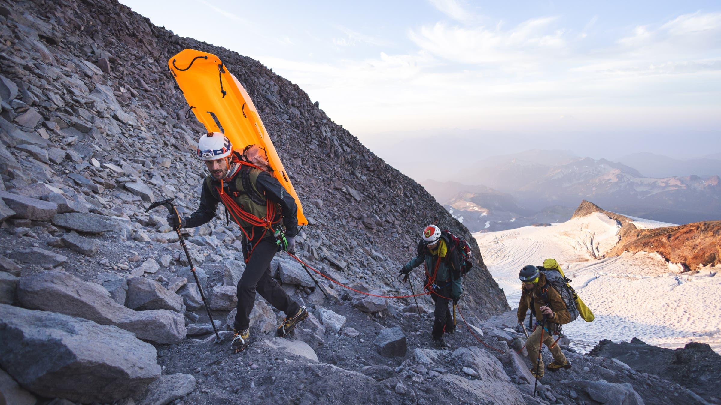
A typical guided climb takes two or three days to go up Rainier. We’re going straight from the parking lot to the top and back in one massive push. The plan hinges on our climbing 1,000 vertical feet per hour for a 10:00 a.m. summit. But so far we’ve managed something closer to 750, which puts us there more like noon—we’ll arrive as everyone else is wrapping up.
Our slowness is largely due to the fact that, in addition to personal food, layers, and climbing gear, we’re hauling three grapefruit-sized GNSS units, three cornstalk-sized tripods to put them on, and an unwieldy, sled-mounted ground-penetrating radar setup that Branden spent the last few months figuring out how to disassemble and stuff into backpacks.
At dawn, we stop to take off headlamps and put on crampons, and the group’s slower members—me and Anthony—discuss whether or not continuing would be a disservice to the team. I am waging a blister war against my rental boots and have lost a lot of territory on my heels. A retreat would be the smarter choice. Anthony—an ultrarunner who has climbed with Eric before—is sucking wind for reasons unknown.
“I don’t know why I’m not feeling it,” he says when he catches up. “I don’t want to jeopardize the mission.”
We encourage Anthony to continue, because if we bail now, our shared gear will weigh down the rest of the team, making it even slower than before. On the other hand, once we rope up and start glacier travel, we will be forced to move as a group. Pretty soon, there will be no turning back without ruining everything, for everybody.
It is strange to think that a mountain’s height might change. They are maybe the original symbol of permanence. From the Brothers Grimm to the Bible, mountains represent eternity. In the Quran, mountains hold the Earth in place.
And yet, you’d be surprised how tricky it is to figure out how tall they are. And how many of the very specific numbers on maps are actually approximations, guesses, or just sort of made up.
In 1856, when the British Great Trigonometrical Survey had identified Mount Everest as the world’s tallest peak and wanted to go on record about it, the elevation kept coming out to exactly 29,000 feet no matter how many times they did the math. They eventually published it as 29,002 feet because a specific but slightly wrong number told a better story than the actual measurement.
Mountains were measured by hand at first, usually by men dragging chains of a known length through the wilderness. Mapping the world’s mountains was painstaking work that took literally hundreds of years. And it was still a little off.
Survey chains stretched over time; surveyors rounded up or down; the numbers were amazingly close, but not exact.
After WWII, photogrammetry—determining elevations by measuring angles in pictures—helped update our maps, but it was better at establishing relative height than taking absolute measurements. Denali, for example, was long thought to be ten feet taller than it really is.
In 2000, NASA’s Shuttle Radar Topography Mission bounced radio waves off the planet’s surface every 30 meters in order to build a map of the world. But because many summits are less than 30 meters wide, there is a pretty significant margin of error. Especially in steep terrain.
Even today, our ability to measure the precise height of a mountain peak is limited by our ability to pinpoint sea level, which is actually more of an idea than a place to hook the end of your tape measure.
The National Geodetic Vertical Datum of 1929 (NGVD 29) was developed to standardize sea level across the country, and was made by averaging tides in 26 locations for nearly two decades.
It was updated to the more modern and accurate North American Vertical Datum of 1988 (NAVD 88), but that turned out to be a little tilted—the datum and sea level grow apart as you move across the country. At the far end, in Washington state, it’s off by about a meter. Sometime this year, most likely, it will be replaced by the North American-Pacific Geopotential Datum of 2022 (NAPGD2022), for which measurements were taken by satellites and aircraft.
NAPGD2022’s vertical reference points are based on a geoid model, which is a theoretical representation of Earth’s gravitational field. Think of it as where the oceans would settle if currents and waves stopped moving the water around.
But even the geoid is not a simple shape, because mass affects the distribution of gravity. That is to say, mountains pull the sea toward them just like the moon pulls the tide. And these are not millimeter effects. There is a particularly un-dense area in the Indian Ocean, for example, where the water has been pulled away and its surface is more than 300 feet below sea level.
So most of the time, when we say a mountain changed height, we mean that technology improved, or we calculated sea level more accurately. Sure, tectonic plates move around, and every so often a volcano gets a drastic new hairstyle, but for most of history, mountains have only grown or shrunk when we have gotten better at measuring them.
Then, sometime around the turn of the century, that was no longer true. Climate change hit a tipping point, and the mountains started melting. Suddenly, when it came to the elevation of ice-capped peaks, all bets were off.
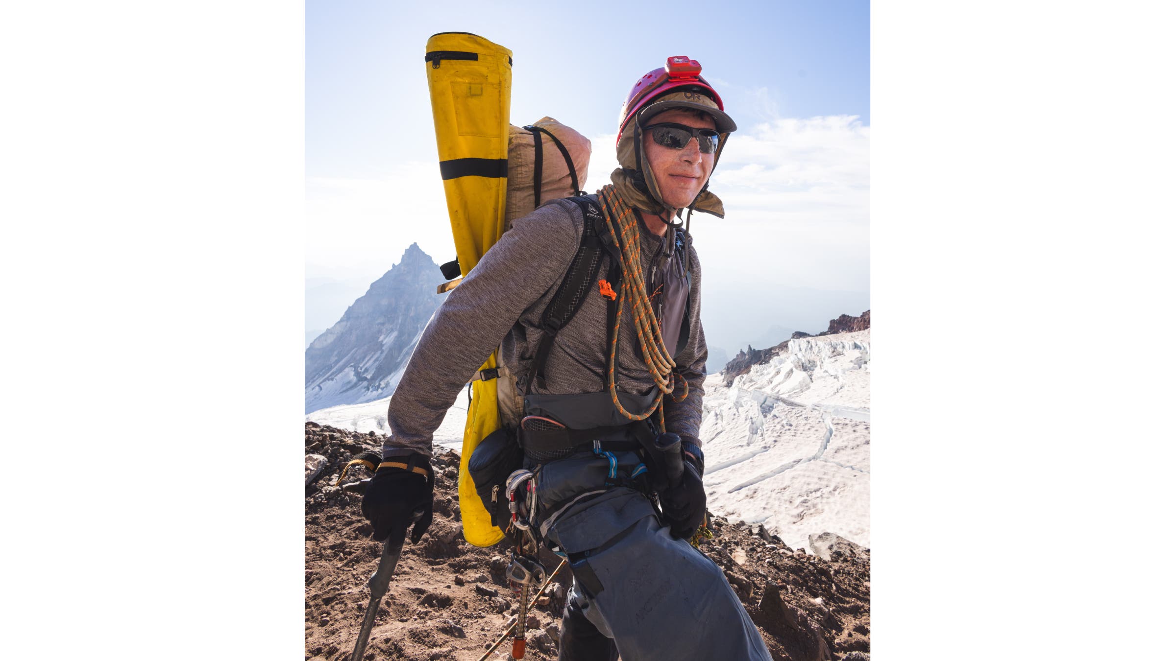
It’s hard to appreciate just how steadily Eric moves uphill until you’re tied to him with a rope. I don’t think of myself as a liability in the mountains, but Eric’s website has a section devoted to his mountaineering speed records. No matter what I do, the rope keeps going taut and I have to yelp for a rest.
We regroup at the top of an aptly named rocky prominence called Disappointment Cleaver to reorganize rope teams and redistribute pack weight. Anthony opted to head back down, so Eric and Scott Clark—our photographer—form an advance party to go ahead and get the GNSS gear set up on the summit. Josh, Branden, and I will follow behind with the ground-penetrating radar.
I give Eric a waterproof layer and some extra carabiners, trying to lighten my load and keep up. He takes something from most everyone, strapping it all on to the top of his backpack, now towering at some new, unmeasurable elevation.
Born in Kentucky, with a bushy-haired resemblance to John Denver and country boy manners, Eric first encountered all this geographic incertitude in college, when he and his twin brother, Matthew, joined the outdoors club at MIT and began to learn all the different ways there were to show vertically significant geology the underside of their boots.
“The mountains are small,” Eric said of learning to climb in New England. “But the weather is bad. It was a good experience.”
In college, they picked off all 48 of New Hampshire’s 4,000-foot peaks. Then they started highpointing the 50 United States, using family road trips to knock out whole sections of the country.
On a three-week break between getting their master’s degrees and starting PhD programs in 2010, they climbed Denali, beginning the project of highpointing every country on Earth.
Over the years, Eric’s climbing résumé became truly world-class. He has now highpointed more than 150 countries, including some of the hardest peaks in the world, like K2 in Pakistan, Pik Pobeda in Kyrgyzstan, Kangchenjunga in India, and Noshaq in Afghanistan, a mountain in a landmined area that had a rumored $7 million bounty for captured Americans.
He is also the third American to receive the Snow Leopard award—for mountaineers who have climbed all five peaks taller than 7,000 meters in the former Soviet Union.
During academic semesters, he will often spend Saturdays going door-to-summit on a mountain in a single 24-hour push. During breaks, he might check off 10 or 15 country highpoints.
It would be wrong to suggest that climbing is Eric’s whole life, however. He has a girlfriend, Katie, and they’ve been together since college. They have dogs and go camping. At one point Eric attempted a world record for the number of objects juggled while unicycling.
Then again, it is difficult to get him to talk about much else. When I ask about other hobbies, he admits it’s mostly stuff that helps him access mountain routes: snowmobiling, snowkiting, running.
“He’s the most efficient person I’ve ever met,” Branden told me at one point. “After a climb there’s no, ‘Hey do you want to get a pizza?’ A lot of times we’ve been up all night and he’s driving straight to work.”
Taking measurements of the mountains he climbed only started in 2017, when a debate about two potential summits on Sherpa Peak, in Washington’s Alpine Lakes Wilderness, had him shooting levels between the two points.
A year later, while preparing for the Saudi Arabia highpoint, he noticed a few discrepancies on some old military maps. He rented some equipment, checked out the two potential peaks, and found that the country’s highest point was actually its second-highest.
He has since surveyed more than 90 peaks around the world and found new highpoints in Uzbekistan, The Gambia, Togo, Guinea-Bissau, Colombia, and Botswana.
Back in Washington, in 2022, he measured Mount Buckner’s double summit and found that the USGS map was pointing people to the wrong one. If they were wrong about that mountain, he thought, what else might they be wrong about?
In the spring of 2023 he checked out an old-but-precise GNSS unit from the civil engineering department at his university, and set out to determine if the Bulgers—a list of the 100 highest mountains in Washington and a common climbing project—was entirely accurate. It was not.
The previous winter, at a party for Bulger-list finishers, Eric had met Ross Wallette. A dedicated climber and mountain photographer, with a beard like he lived in the mountains full-time, he could keep up with Eric while shooting photos and video.
Eric and Ross started climbing together, and the GNSS equipment felt like a superpower. There were plenty of corrections to make, and it was another reason to be in the mountains.
Eventually, Eric heard from some guides that when you stood on what had always been considered the summit of Rainier, it sure didn’t seem like the top. Eric said he’d look into it, and he remembers Ross jumping at the chance to document the project.
“I mean, it’s Rainier,” Eric said when I asked him why this mountain was so important. “We should know how tall it is.”
Indeed, Rainier is special. It’s on Washington’s license plate. It’s the namesake of an unpretentious lager. It’s one of just five mountains in the lower 48 taller than 14,400 feet. In Seattle and its suburbs, it is simply referred to as “The Mountain.”
In August of 2024, Eric and Ross went up to take its measurements.
14,399.6 feet.
The previous measurements weren’t wrong. The mountain was shrinking.
“Eric did a pretty good job,” said Larry Signani, the surveyor who measured Rainier in 1988 and 1999 with GPS and processed the data from Eric’s 2024 measurements. “He’s a pretty thorough individual.”
His only mistake, as far as anyone can tell, is that after Larry confirmed his numbers, Eric put them on the internet. And the internet was skeptical.
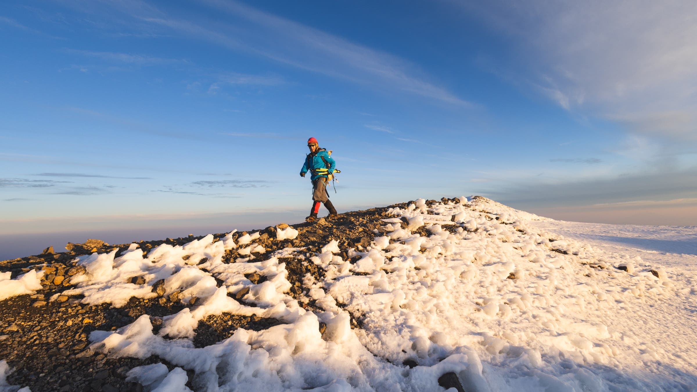
It is well past noon when we make the top, a circular crater maybe a quarter mile around. The other teams on the mountain have delayed their start times accordingly. We find Scott collapsed behind a rock, out of the wind. He doesn’t know where Eric is or how long he’s been gone.
Historically, the true summit has been a mound of ice on the northwest side of the rim called Columbia Crest. This is where surveyors have always measured from. What Eric found in 2024—what the climbing guides had noticed already—is that sometime after the 1999 GPS survey, it had started melting.
The mountain’s highest point was now a cooler-sized rock about 150 yards away.
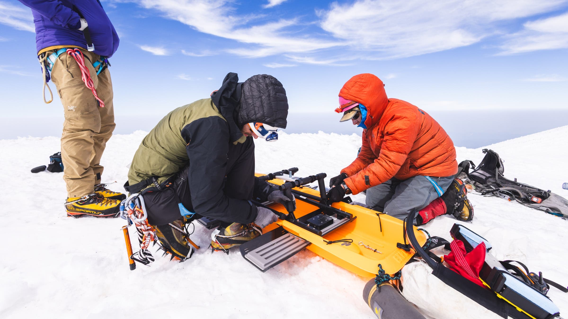
This is where we find Eric, setting up tripods, getting ready to start recording data. Branden and Joshua begin assembling the ground-penetrating radar. If Columbia Crest is melting, the obvious question is: How much ice is left, how long until it disappears completely?
Scott and I sprawl out to watch, completely spent. Eric is a picture of efficiency. There is so much to do.
In 2024, after measuring Rainier in late August, Eric tried to spread the word. He published the data on his website, he posted his findings on Instagram. Presumably, someone saw his work and tried to edit Mount Rainier’s Wikipedia page—Eric doesn’t know who it was.
But given the timing, it sure looked like Eric had done it.
“There is no place on Wikipedia for the data that you are trying to add,” wrote an editor.
Eric didn’t want to talk about this controversy, but it played out in Wikipedia’s “Talk” section. You can look it up.
Mount Rainier National Park geologist Scott Beason weighed in, urging Wikipedia’s editors not to accept Eric’s survey until the park could analyze it. This was an individual, he said, taking a single measurement. It couldn’t be trusted.
That wasn’t quite true, as Eric had already measured twice, once in August and again in September, but the point stood. The park also asked Eric to add a disclaimer on his website that his results weren’t “official.” He did, but then Wikipedians used it to discredit the accuracy of the measurements.
At one point Eric linked to his raw data as if to say, The numbers don’t lie. What more do you want from me?
What the editors wanted, per Wikipedia policy, was expert analysis or reputable media coverage that they could link to.
They were in luck. Through the fall of 2024, Eric gave interviews to a handful of news outlets, most notably the Seattle Times. But as the primary—sometimes only—source for those articles, he was again rejected on the grounds that being quoted in a newspaper article does not make you a subject matter expert.
“At the end of the day, individuals cannot simply travel around making field observations and then attempt to install them on Wikipedia,” wrote an editor.
“If Gilbertson wants to publish his work in a peer-reviewed academic journal, it would hold more weight here,” wrote another.
A couple of people eventually came to his defense in the comments, but the onslaught wasn’t over. Because then, Seattle’s near-celebrity meteorologist, Cliff Mass, took issue with the Seattle Times coverage.
He didn’t think the summit of Rainier was melting at all.
In a long blog post, he called the Seattle Times article “error-filled” and “untrue.”
“Global warming does not decrease snowpack at 14,000 feet,” Mass wrote when I asked about it. “Too high and cold.”
I ran this idea past Mauri Pelto, a glaciologist and professor at Nichols College, who has studied Washington’s glaciers for the last 43 years.
“I guess he hasn’t been up there recently,” Pelto said. Records of weather forecasts indicate that there were 35 days last summer when the summit would have been above freezing for part or all of the day. “There was a period where temperatures at the summit didn’t get below freezing for six days,” he said.
Mass’s argument relies on climatology and data from a weather station 150 miles from Rainier. And if you read his post carefully, he doesn’t actually dispute the loss of height. Just that global warming is the cause.
In any case, the multipronged critiques seemed to rankle Eric. His data was good. And he was getting a lot more of it.
While all this was happening, he and Ross had climbed and surveyed the four other ice-capped peaks in the lower 48, which all happen to be in Washington—Colfax, Liberty Cap, Eldorado, and East Fury. All had melted down around 15 to 30 feet. All but two were no longer ice-capped.
In December 2024, Eric spent two weeks in Colombia measuring its two tallest mountains and found that both had lost more than 170 feet of ice since they were surveyed in 1939. In fact, the previous highpoint—Pico Cristóbal Colón—turned out to be significantly shorter than the new highpoint, Pico Simón Bolívar.
In late 2024 and early 2025, he began writing up his findings and submitting them to academic journals. He stopped engaging with the Wikipedia debate. He kept posting on Instagram. The geospatial technology company Trimble saw his work and sent him a smaller, lighter GNSS and started processing the data he gathered.
As summer approached, Eric and Ross began to organize climbers to help them remeasure the peaks in Washington, which can only be done in late summer and early fall, after the mountains have fully melted out, but before the snows come.
Climbing five mountains as quickly as possible and staying at the summit for two-plus hours every time is a formidable project. With Eric’s travel schedule, it would have to be done in eight days.
Ross reached out to his network of climbing buddies and found a crew to haul gear up the different peaks. I reached out to Eric and asked if I could follow everyone up Mount Rainier.
Four days before the climb, however, I got an email from Eric. It was a report from his trip to East Fury, and a nearby rock spire called Fury Finger.
“Very bad news,” he wrote. “Ross Wallette fell near the summit and did not survive.”
With all the accolades for his alpinism, all the bags packed and peaks bagged, it’s tempting to think of Eric as some kind of Greek god of mountain climbing, winning fame and glory on summits around the world.
But that’s not always how it works.
The government of Saudi Arabia has not acknowledged his alternative highpoint, for example. Guinness chose not to recognize his unicycling world record. He had to petition the Russian Mountaineering Federation when they doubted one of his Snow Leopard summits.
And sometimes he simply fails.
On a technical mountain called Shkhara, the highpoint of Georgia, Eric and his twin brother got slowed down by ice and couldn’t summit before a storm blew in. In Madagascar, on a brutally hot trip with his brother and both of their partners, the group split up after an argument about water treatment, and aborted the climb when almost everyone got sick.
In 2023, Eric failed to reach the top of Everest while attempting it without supplemental oxygen or climbing sherpa support. After dislocating his shoulder in the Khumbu Icefall, he kept going, developed a respiratory infection, and had to be flown to a nearby town to recover. After a week he went back up to Base Camp, tried again, and turned back about a thousand feet from the top when he started showing signs of high-altitude cerebral edema.
His written reports on these expeditions are matter-of-fact and often understated to the point of self-parody. “Manhaul 4 sleds each (400 lbs.) 35 miles up ice cap,” he wrote about a snowkiting traverse of Greenland with Branden. “Ride out three-day rain event in tent.”
The economy of language can be mistaken for arrogance. Sometimes I wonder if Wikipedia’s resistance to Eric’s Rainier measurements comes down to a reluctance to describe mental and physical suffering.
Another way to look at it is storytelling limited to the quantifiable. His numbers, however, aren’t always perfect.
In one of our interviews, I understood him to have climbed Denali in 2012, when it was actually 2010. In the write-up of his first Rainier survey, he said that Larry Signani’s second GPS survey of the summit was in 1998. It was in 1999. (He corrected this when I pointed it out.)
This mistake was repeated in several news articles and included in an academic paper.
In other words, they are minor errors, the kind that creep into any human endeavor. But they are a reminder that Eric is, in fact, human.
It was a haunting accident. A hold that tore away as Ross climbed Fury Finger. Ross and another friend had gone in a day early to do some cragging before helping survey it the next day. When Branden couldn’t make the climb, Eric hiked in 70 pounds of equipment 25 miles by himself. He was a mile away, crossing an exposed ridge, when he saw a helicopter long-lining a body off the mountain.
Eric never mentioned Ross on the Rainier climb. No one did.
Instead, everyone climbed and worked like they were doing him proud.
Once a GNSS was up and running on the summit and the ground penetrating radar had measured the ice on Columbia Crest, Eric, Branden, and Josh packed it up again to go measure Liberty Cap, a peak about a mile away and one of the two mountains in Washington that are still ice capped. It took them about three hours to climb, measure, and return.
By the time they did, we’d been on the summit for eight hours. It was fully dark by the time we began our descent, hiking like mad through the night, stumbling back just after sunrise to a parking lot quickly filling with tourists.
It took me just about as long to recover physically—months—as it did for Eric to process all the data. In the meantime, two academic journals published Eric’s 2024 survey results, which matched the data from our 2025 climb. Rainier’s new, rocky summit remained at 14,399.6 feet in the older NGVD 29 datum; 14,406 feet in NAVD 88. Eric had also gotten a sneak peek at a preliminary version of NAPGD2022 via Trimble’s engineers, and said Rainier’s updated height would probably be somewhere in the middle, just a foot or two above 14,400.
Columbia Crest, meanwhile, was melting at a remarkably linear 0.9 feet per year. It probably lost its status as Rainier’s true summit sometime in 2014. It would be gone by 2045.
Liberty Cap would likely be the only mountain with a perennially snow-covered summit in the lower 48 by the end of this year. If nothing changed it would melt completely by 2046.
Wikipedia was still a brick wall. Despite the peer-reviewed publication, editors didn’t like the fact that Eric’s data used NGVD 29—to align with Mount Rainier National Park’s official measurement—while the edit on Wikipedia was in NAVD 88. Nineteen twenty-nine was out of date, they said. But the 1988 datum wasn’t what the national park used, so it wasn’t appropriate. He couldn’t win.
The national park, meanwhile, still hadn’t gotten back to him about whether they were going to accept his data, do their own survey, or what.
When I contacted the park, it said that its geologists had written a response to Eric’s academic paper published in the journal Arctic, Antarctic, and Alpine Research which published Eric’s 2024 data. A spokesperson ignored multiple interview requests but shared a summary of the article’s main points shortly after the print version of this story went to press. The critiques mostly came down to messaging. It asked for clearer communication and distinction between things like ice and bedrock elevations, vertical datums, and measurement methods. There was nothing to suggest that the measurements themselves were suspect.
When I asked Trimble what some potential concerns might be, they said the only thing that realistically might have screwed up the data was if Eric hadn’t set the pole up perfectly straight, which might alter the measurement by a few centimeters.
Even if Eric’s data is perfect, however, it won’t convince the National Geodetic Survey, which requires two different sets of consistent measurements, usually taken on two different days, in order to benchmark a new position in their database. In other words, Eric has to do it all again this August.
When I finally asked Eric about Ross, and how a death in the mountains changes how someone thinks about measuring them, he was silent for a long time.
Ross accompanied Eric on all but one climb for this project in 2024. His photos appear in the media coverage. He was, it seems to me, shoulder-to-shoulder with Eric in his uphill battle to correct Rainier’s height. And it seems to me like the loss of a friend who repeatedly ventured into the mountains to gather information about the world would make the judgments of armchair skeptics on the internet even more infuriating.
It seems to me like this whole project started out as a simple quest for precision and accuracy and better science, but over time became something kind of precious and rare: a small but real way that the two of them could push back against a world of melting ice.
But I don’t actually know.
All Eric said was, “I don’t want to talk about that.”
Instead, we talked about processing the data we’d gathered, how four different measurements had now been verified by three different people, how he’d compared them to three different reference points, and gotten the same result six times.
Because you’d be surprised how tricky it is to figure out the actual height of a mountain; how difficult it is to talk about loss in a way that won’t be torn apart online. It’s hard to believe sometimes how many of the very specific numbers on maps are actually approximations, guesses, or just sort of made up. Some things can’t be measured. Even the best numbers don’t always tell the full story.
This article is from the Summer 2026 issue of Outside magazine. To receive the print magazine, become an Outside+ member here.